The straight looking coast is however quite jagged, marked by a large number of coves (small sheltered recesses in the coast) and creeks(small tidal inlets or estuaries of small streams). A large number of small streams descend from the precipitous Western Ghats and flow through the narrow coastal plain to open into the Arabian Sea.
Although the streams are small, some of them have formed spectacular waterfalls. The Konkan coastal plain is cliffy and there are several shoals, reefs and islands in the Arabian Sea. Mumbai was a large island but parts of the sea have been reclaimed in recent years to connect it with the mainland. There is a submerged forest near Mumbai which suggests that the sea level rose on the Konkan coast not long ago.

The coastal plain is dotted with flat-topped hills. Transverse flat-looped spurs come down almost to the shoreline from the edge of the plateau and dip into the sea at Karwar, the northern part of Karnataka. These appear to be abrasional platforms, now dissected by the west flowing streams.
It is only on the Malabar coast that there are seen a number of lakes, lagoons and backwaters which form a noteworthy feature of the coast. These backwaters, locally called Kayals, are shallow lagoons or inlets of the sea, lying parallel to the coastline. The largest among them is the Vembanad Lake, which is about 75 km long and 5-10 km wide; it gives rise to a 55 km long spit. Cochin harbour is situated on its opening into the sea. These backwaters form important physical as well as economic features of the Malabar coast, affording facilities for inland water communication. The silt brought by recurring monsoon floods support large forests and plantations along the shores. There are remarkable mangrove swamps lining the coast.


 Sunset at Maravanthe, Karnataka - Pic by Mohan Pai
South of the Palghat Gap the coastal zone constituting Travancore varies in width between 30-50 km.
The tropical monsoon climate covers the entire coastal belt. The Western Ghats greatly influence the climate and separate the west coast from the dry interior upland. The elevated Ghats obstruct the monsoon winds from South West and the orographic effect is considerable. Rainfall on the coast is extremely heavy during June-September averaging 100 inches (2,540 mm) with some of the wettest spots recording 300 inches (7,500 mm). The duration of the dry season gradually increases from two months in the southern parts of the Ghats to over eight months north of Mumbai.

Kerala is directly exposed to the southwest monsoon but also receives rains from the reverse (north east) monsoon. And for this reason the dry seasons towards the south are shorter.
A Coast of Maritime Legends
The maritime history of the West Coast of India predates the birth of Western Civilisation. The world’s first tidal dock is believed to have been built at Lothal around 2,300 BC during the Harappan civilisation near the present day Mangrol harbour on the Gujarat coast. Even before Alexander, there were references to India in Greek works and India had a flourishing trade with Rome. Roman writer Pliny speaks of Indian traders carrying away large quantities of gold from Rome, in payment for much sought exports such as precious stones, skins, textiles, spices, sandal wood, perfumes, herbs and indigo. It was the lure of spices that attracted traders from the Middle East and Europe to the many trading ports in Kerala - Calicut, Cranganore, Cochin, Alleppey and Quilon - long before the time of Christ. And it is believed that it was on a trading vessel plying between Alexandria and the Malabar that St. Thomas, the Apostle arrived in Cranganore in 52 AD and began preaching the Gospel and established seven Christian communities in Kerala.
From the earliest times, the West Coast had developed a considerable shipbuilding industry, specialised in building large vessels. There are several accounts of such activities including that of Marco Polo who has described the Indian built ships.
European interest in India has persisted since classical times and for very cogent reasons. Europe had much to derive from India such as spices, textiles and other Oriental products. When direct contact was lost with the fall of Rome and the rise of the Muslims, the trade was carried on through middlemen. In the late Middle Ages it increased with the prosperity of Europe. Spice trade was not solely a luxury trade - spices were needed to preserve meat through the winter (cattle had to be slaughtered in late autumn through lack of fodder in winter) and to combat the taste of decay. Wine, in the absence of ancient or modern methods of maturing, had to be ‘mulled’ with spices. This trade suffered two threats in the later Middle ages. There was the threat of Mongol and Turkish Invasion which interfered with the land route through Egypt, and there was the threat of monopoly shared between the Venetians and Egyptians.

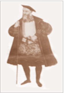.jpg) Vasco da Gama
Vasco da GamaVasco da Gama set sail on July 8, 1497 with four ships and 170 men, rounded the Cape of Good Hope four months later, and reached Kappad twelve km north of Calicut on the Malabar coast of Kerala, on May 17, 1498. Calicut then was a busy sea port, where the Arabs and the Chinese met to exchange the products of the west and the east.
 Memorial to Vasco da Gama, Kappad beach near Calicut - Pic by Mohan Pai
The Moors in Calicut instigated the Zamorin against Vasco da Gama, and he was compelled to return with the bare discovery and the few spices he had bought there at inflated prices (but he still made 3,000% profit !). A force left by a second expedition under Cabral (who discovered Brazil by sailing too far west), left behind some men in a “factory” or trading station, but these were killed by the Moors in revenge for Cabral’s attack on Arab shipping in the Indian Ocean. Vasco da Gama was sent on a mission of vengeance in 1502, he bombarded Calicut (virtually destroying the port), and returned with great spoil. His expedition turned the commerce of Europe from the Mediterranean cities to the Atlantic coast, and opened up the east to European enterprise.
The Portugese eyed the Arab monopoly of Indian spice trade and tried to overthrow the Arabs. They succeeded after continuous battles with the Arabs for twenty years. Cabral, who led the second voyage established the first Portugese factory at Cochin. Francisco de Almeida, the Viceroy of Portugal (1505-15) built forts in Anjediva and Cannanor. In the year 1510, Afonso de Albuquerque captured Goa and developed it into a great trading centre, particularly for importing
 Basilica of Bom Jesus, Old Goa - Pic by Mohan Pai
Arab horses. Apart from Calicut (1510-1616) and Goa (1510 -1961), the other Portugese possessions on the west coast included Bombay (1530-1664), Diu (1535-1961), Surat (1540-1615), Damao (1558-1961) and Bhatkal (1560-1637) .
In 1534, Sultan Bahdur Shah, the ruler of Gujarat ceded the island of Bombay to The Portugese and in 1661 it was given as a marriage dowry to King Charles II when he married the Portugese Princess, Catherine of Braganza. The crown ceded it to the East India Company in 1665.
During the fourth Mysore War (1799) between the British and Tipu Sultan of Mysore, Tipu was defeated and killed and among the other territories, the coastline of Karnataka came under the British rule. By the year 1818, the Marathas were completely subdued and their territories annexed by the British which also included most of the west coast of Maharashtra. The West Coast was now completely under the British regime with the exception of few pockets under the Portugese (Goa, Damao & Diu), the French (Mahe) and the Travancore coast.
Today, the west coast represents one of the most developed areas, both industrially and economically, of the country with four major ports - Mumbai, the largest port in the country, Marmugao, Mangalore and Cochin. Mumbai is the financial capital of India and also an important industrial hub with a population of over 12 million. A major Naval Base is taking shape at Karwar.
Apart from the major ports the entire coast is strewn with smaller harbours all along. It’s also a high population density area with Kerala having the highest population density in the country.
Surat southward, the coast is connected by National Highway 8 up to Mumbai and then by NH 17 - Panvel-Mangalore-Trissur. From Trissur NH 47 takes over and goes up to Kanyakumari. Konkan Railway, the west coast railway route was launched in January, 1998. Konkan Railway line connects Mumbai to Mangalore with a distance of 760km. It connects the three states - Maharashtra, Goa and Karnataka through the mountainous terrain of the Western Ghats. It goes through 92 tunnels and crosses nearly 1700 bridges and traverses through one of the most picturesque region of the west coast. Surat downwards the west coast is dotted with innumerable beaches interspersed by estuaries of the west flowing rivers, creeks and shoals.
The more famous beaches are that of Goa and Kerala which have been attracting considerable tourist traffic - both international and domestic.
The popular west coast beach destinations are as follows:
Maharashtra * Juhu * Marve-Manori* Alibag* Murud * Janjira * Kihim * Ganapatipule* Sindhudurg* Vengurla* Malvan
Goa
* Calangute * Baga * Colva * Anjuna * Vagator * Arambole * Palolem Karnataka
* Devbagh * Om & Kutle (Gokarna)* Murudeshwar* Malpe* Maravanthe* Ullal
 Karwar shoreline - Pic by Mohan Pai
 * Bekal * Kappad * Varkala * Cherai * Kovalam* Alleppey

3 comments:
This is really awesome :)
Looking For Car Rental Goa, Visit
Rent a Car in Goa
This is really awesome :)
Looking For Bike Rental Goa, Visit
Bike Rental Goa
Sccoty on Rent in Goa
Keep posting like those amazing posts :)
Looking For Car Rental Goa, Visit
Car Rental in Vasco Goa
Post a Comment